
Isle Royale in a Cool Late August
Hiking Isle Royale is a great experience at any time of year, but Lara, Jennifer, and I had an exquisite experience with the cool weather in late August this year. We arrived on the Queen IV at Rock Harbor, caught a hop on the Voyageur II to Chippewa Harbor and hiked back to Rock Harbor via the Rock Harbor Trail with one diversion from Daisy Farm up to the Greenstone Ridge Trail to view the Ojibway Tower and across to the lookout at Mt. Franklin, finally dropping back into 3 Mile Campground.
The excursion was six days and five nights, longer than what is needed for a simple Daisy Farm Loop, but not long enough to traverse the length of the island. Thus, the hop to Chippewa Harbor was a great compromise. It afforded Jennifer, an experienced backpacker, the challenge of a five-day hike over the rocks and roots of Isle Royale while allowing Lara, an avid runner and adventurer, a moderate excursion for her first backpacking experience.

Bound for Rock Harbor

Bound for Chippewa Harbor
As with all outings, we started out with a couple of Zoom meetings to ensure proper gear and preparation, but we were all strangers at the start. We met in Copper Harbor the night prior to departure aboard the Queen IV, reviewed safety protocols and weighed in our packs, making last-minute tweaks to keep weights manageable.
On the morning of departure, a small craft warning was in place with waves on Lakes Superior between 6 and 10 feet; with an abundance of caution, the captain delayed our departure from 8:00 AM to 2:00 PM. To pass the afternoon, the ladies explored Copper Harbor, enjoying lunch at the Mariner North.
Once we departed, Captain Craig Funke navigated the wavy seas expertly while crew member Amy attended to passengers, handing out Dramamine and plastic bags as requested and needed. Captain Ben Kilpela’s cheerful smile assured passengers that all was well on board the Queen IV. A group of adventurers stood out on the back deck throughout the crossing as the waves still reached four feet, rocking the vessel.


About the vessel, passengers lolled in their chairs from Dramamine or kept their eyes on the horizon, willing back their nausea. Others chatted in their separate groups, murmuring about their plans for the next days. Linkages had not yet formed across groups and goals had not yet been shared with others. We were separate people with common goals, but we had not yet connected with one another.
Fortunately, the waves abated as the trip progressed, and we motored into a calm Rock Harbor by early evening where Lara, Jennifer, and I spent the first night set up in tent site 13, tucked deep into the pines in the campground at Rock Harbor. Prior to darkness setting in, we stretched our legs by hiking out on the half loop on the Stoll Trail toward Scoville Point. The late hour, though, kept us from reaching the trail terminus at Scoville Point.
We enjoyed our first dinner together, dehydrated meals–chicken risotto, chicken alfredo, and deli roast beef–each trying a new brand or a new dish. In headlamps, the group mastered the challenges inherent in the assembly of new stoves and use of new gear. We assembled tents and blew up sleeping pads, spread out sleeping bags, and located pillows and sleeping gear. The evening was a hubbub of activity in our site and in the ones surrounding us.

the Ridge at Chippewa Harbor

The next morning, we continued our journey on to the starting point of our hike. After boarding the Voyageur II, we departed the dock just prior to 9:00 AM Eastern, dropped a few backpackers at Daisy Farm, and headed through Middle Islands Passage, past the Rock Harbor Lighthouse, and on toward our destination. We landed in Chippewa Harbor just past 10:00 AM, and quickly ascertained that we wanted to get started on our excursion to Moskey Basin as we had spent the previous day waiting for departure or sitting in the boat for the four-hour crossing.
Before departing Chippewa Harbor, however, we dropped our packs and walked up to the Johnson Schoolhouse, exploring its tiny structure and surrounding area. Both ladies were astounded by the tiny size of the school, surmising that only a few students might have attended the school at one time. From the schoolhouse, we hiked up to the ridge to view Lake Superior to the south, the harbor in front of us, and to the east Lake Mason. Both Lara and Jennifer took the time to text friends and family from the ridge. I did, too, sending smoochy faces to Duane.
We set out to Moskey Basin a little before noon, excited to find our trail legs and get into the groove of hiking. I kept a watchful eye on the group as we crossed over boardwalks that spanned swampy areas and beaver ponds and navigated the rocky, rooty trail that led to our first destination. Our average speed was nearly 2.5 mph.
Moskey Basin was lovely as always, and we were fortunate to find Shelter 3 open so late in the day. We arrived at the end of our 6.2-mile hike in the mid-afternoon, without issue, and set up our tents inside the shelter to keep warm over the cool night. Loons and moose calls echoed across the water in the late afternoon.


Next to us was another hiker who was returning to the island after a 20-year absence. He reclined against his pack, stretched long as the evening as loons laughed in front of us. Soon, he and Jennifer were exchanging stories of past hiking excursions, his to Isle Royale and hers to Machu Pichu in Peru and other destinations. He was off to complete the Greenstone, but he was going next to McCargoe Cove. After a lively evening of chatter, we all were ready to wash up for sleep.
Rain was forecast for the next day, so we wanted to find a shelter in Daisy Farm for the next evening and night. I set an alarm to ensure we started early enough to be able to have a chance to secure a shelter. After about thirty minutes, our neighbor came out again and asked if there were shelters at McCargoe Cove. Yes, I said. There are six. I smiled. So did he.
As with every morning after, we were up at 6:30. While we packed up, we did not see our neighbor, and sounds of sleep emanated from his shelter. Quietly, we were on the trail shortly after 8:00, each nourished by a cup of coffee and a breakfast bar. We traversed the rocky and uneven trail with an average speed of slightly more than 2 miles per hour.

Along the way, we met backpackers on route to the Greenstone Ridge via the Indian Portage Trail and day hikers from Daisy Farm enjoying an easy outing to this low ridge that affords an elevated view of the long harbor that extends from Moskey Basin to Rock Harbor. In the process, we met a minimum of three women-only hiking groups and three or four family groups or couples. The diversity of hikers warmed my heart. By 1:30 that afternoon, we were setting up in Shelter 1 at Daisy Farm.
Once in Daisy Farm, Jennifer and I went to the dock to filter water. Then we set up camp and had a snack for lunch. Always the explorer, Lara discovered the trail to the Ojibway Tower, the beaver dam and what lay beyond, and the ranger residence to the west of the campsite, a quaint structure with solar panels as a source of power. While I took a short swim, both ladies took the opportunity to visit with others on the dock.


There, they met a couple of powerhouse women who had managed to carry 45-pound packs from Rock Harbor to Daisy Farm on the day that we arrived. Like us, they come in on the delayed boat from Copper Harbor. On that same day, they hiked directly to Daisy Farm, arriving after 10:00 PM with headlamps. Because of the heavy pack weight, one of the two women bruised her arm when putting on and removing her pack, the red-black bruising visible below the short sleeve of her tee-shirt. At the end of the first day, they dug out their luxury items, a flask of whiskey and a pint of bourbon. Affectionately, they became known to us as the “whiskey ladies.” Even while we felt for them in their struggles with those heavy packs, we also admired their stamina, for it is no small feat to port 45 pounds for 7.2 miles, the distance from Rock Harbor to Daisy Farm.
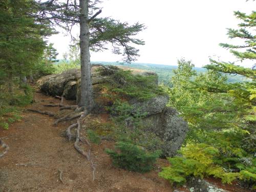
Leaving Daisy Farm, we decided to ascend the Greenstone Ridge to the Ojibway Tower. The trail to the tower passes over a couple hills and across a couple boardwalks that span a creek and a swampy area. As we crested one hill, we walked up on a cow moose.


She stood looking at us with her ears forward. Still, we backed away so that we might not cause her to change her mind and lay her ears back. She passed into the woods across the trail and disappeared. A few paces along, we saw her through the trees. She looked out at us patiently while we zoomed in with our cameras to take photos.
All along on Isle Royale, the trails cross over or go around impediments. Those ascending to the Greenstone Ridge use boardwalks to traverse swamps and beaver ponds. With the lack of water due to draught and predation of beavers by wolves since their reintroduction, many swampy areas are low, so the boardwalks seem to tower over the low water beneath them, creating an illusion of extended height. Three feet and more of the vertical supports of one of the boardwalks were visible as we made our way across and on toward the Ojibway Tower.


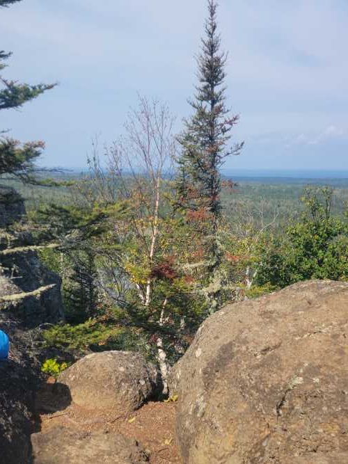
Both Jennifer and Lara ascended the tower as high as they could go while I stayed on the ground to capture them on film. They took photos to the north and south, capturing both Canada and extended views of Lake Superior, respectively. We met Michael who day hiked toward Mt. Franklin with us. Like the “whiskey ladies,” Michael had hiked to Daisy Farm directly from the boat in Rock Harbor. Apparently, he and his friend John were also on the Friday boat out of Copper Harbor. Michael went on ahead of us toward Mt. Franklin.
From the tower, we made the hike to Mt. Franklin, stopping at a number of lookouts to take photos and text friends. On our way, we met Michael again on his way back down to Daisy Farm. At Mt. Franklin, we we enjoyed lunch. We visited with day hikers from the Rock Harbor Lodge who had taken the Sandy tour boat to Hidden Lake Dock, climbed up to Lookout Louise, and hiked over to Mount Franklin for one of the best views on the island.

From the top of Mt. Franklin, Jennifer and Lara exclaimed at the views looking toward Canada. Finally, we hiked .3 miles toward the junction to the Mt. Franklin Trail. While we considered hiking into Lane Cove, we chose to proceed to 3 Mile campground. We had hiked a lot and were ready to end our 7.2-mile day with a waterfront tent site on the Rock Harbor side of the peninsula, so we descended the steep trail to the junction with the Rock Harbor Trail just outside the campground.

Given that we did not arrive until 3:00 PM, we were not surprised that the shelters were filled, but we were pleasantly surprised by the beauty we found at tents site 9. That evening, we found ourselves relaxing at the picnic table, but the temperatures dipped as the shadows lengthened. To preserve the time for visiting, we climbed onto the rocks between site 9 and shelter 10, catching the last hour of sunlight.
Eventually, we were driven from the rocks by the cool air of dusk. The temperatures dropped that night into the low 50s or upper 40s. We did not have a thermometer to verify, however. That night, we all slept in our base layers and outer clothes as well as our puffy coats, hats and gloves–this even in our 15-degree sleeping bags. Still, from our campsite on the shore the sunrise was extraordinary.

From 3-Mile Campground, we continued into Rock Harbor. We knew that the Ranger III and the Queen IV had both been delayed a day, so we started early in hopes of acquiring a recently vacated shelter before others arrived to occupy them. We were pleased to land in Shelter 6 and set up quickly.
We enjoyed visiting with other hikers as we had dinner at the Greenstone Grill. It was amazing how good a simple burger tasted after a few days of dehydrated meals. At the grill, we also ran across the day-hikers from the Mount Franklin lookout.


Prior to the regularly scheduled departure at 2:45 on the Queen IV, the three of us hiked out to Scoville Point to complete the journey we had started on the day of our arrival. There, we ran across Michael and a number of day hikers again at the end of Scoville Point. We all took each other’s photos and hiked together back to Rock Harbor, taking the forested loop that passes by the Smithwick Mine where Michael and Jennifer saw two red foxes.

Back in Rock Harbor, we lunched at the Greenstone Grill before returning to our shelter to pack up. We dropped our packs at the dock and took the last few minutes to purchase snacks for the ride at the Rock Harbor Store. To our delight, we found the “whiskey ladies” in line just a few feet behind us in line. By the time we handed up our packs and boarded, we found ourselves sitting with the ladies and Michael as well as Michael’s friend John who had struggled during the hike and ended up renting a boat with an outboard motor instead of doing a lot of backpacking.
In spite of the hubbub of boarding, we also met some day-trippers, a couple in their early 70s, who came out to enjoy the day on the boat and a nice meal at the grill. It reinforced our awareness that there are many ways to experience this beautiful gem of an island. At adjoining tables shared among our larger group, Jennifer, Lara, and I found ourselves amid a din of voices, all sharing the successes of our current adventures and aspirations for next excursions on the island.
What started out with a group of strangers ended up, I hope, as an adventure among and with friends.